
Processes in convective clouds take place on scales from millimeters to several kilometers, but present-day regional climate models only resolve scales of 10 km and larger. Clearly something has to be done to represent these cloud processes that are not resolved, and this “something” is called parameterization. In a parameterization an estimate of the effect of the processes in convective clouds in terms of the quantities resolved by the model is computed. For instance, the transport of heat and moisture in the convective cloud is expressed as a parameterized function of the mean vertical gradients of heat and moisture in the atmosphere and a measure of vertical instability. These parameterizations are based on measurements and physical understanding; they can be rather complex and they appear to work reasonably well in the daily practice of numerical weather prediction. Yet, it is also known that in climate models parameterizations of clouds are responsible for a major, if not the largest, source of uncertainty. The spread in the response of the global mean temperature to a doubling of CO2, the so-called climate sensitivity, in global climate models is primarily determined by uncertainty in cloud parameterizations. Here, we look at a different aspect. Results obtained here show that these parameterizations employed in regional climate models do not represent to sensitivity to absolute and vertical humidity very well. This is most likely related to the fact that the meso-scale dynamics involved with these convective clouds is inherently three dimensional, whereas parameterizations only represent the vertical dimension (1D).
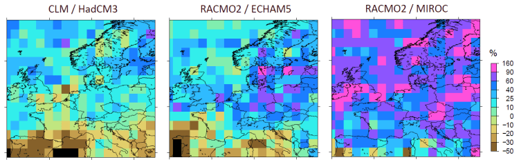
Regional climate model simulations show a wide range in projected increases of hourly precipitation extremes for the end of this century: from almost no increase (left) to +60-80% (right panel) for western Europe. Part of these differences are due to the global climate model (HadCM3/ECHAM5/MIROC) that is used to drive the regional model. A considerable part however is due to the parameterizations of convective clouds and precipitation that are employed in the regional climate models. In particular, (extreme) precipitation in most models appear to be much too sensitive to small decreases in relative humidity as compared to the observations (see paper in Environmental Research Letters). The block pattern is not the native model resolution (which is 25 km), but results from the analysis technique where changes in 2° by 2° (latitude-longitude) blocks are computed at the same time.