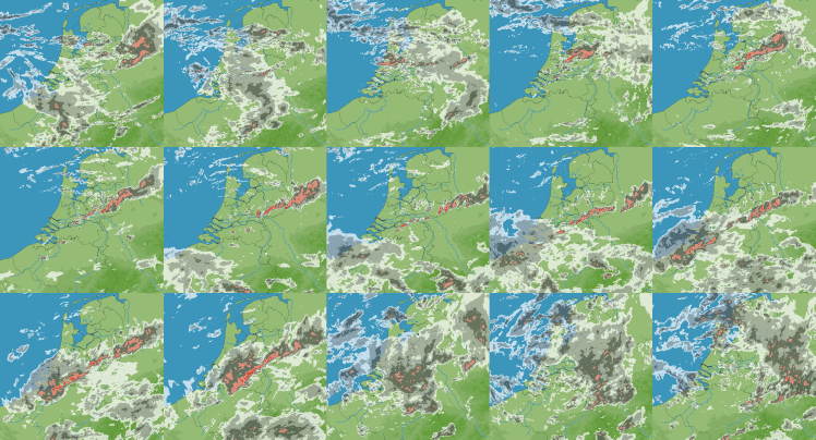
On the 26 and 27 August 2010, a series of showers embedded in a large scale low pressure system produced more than 130 mm of rain in the Eastern part of the Netherlands and western part of Germany.
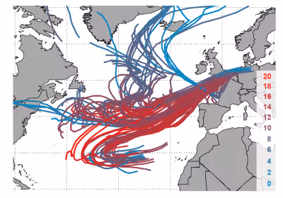
To understand this type of precipitation extreme it is important to know where the water that rained out during this event originated from. In summer the atmosphere typically contains 20 to 30 litres of water per m2, in the form of water vapour, when integrated from the surface to the top of the atmosphere. Converted to rain this is equivalent to 20 to 30 mm. Therefore, it is clear that in this case only part of the rain that fell was contained locally in the atmosphere, and that the transport of water vapour by the atmospheric motions must have been important.
Tracking of air parcels that produced the heaviest rain on the 26 August 2010. The most moist parcels are red, whereas drier parcels are cyan. It is shown that a large part of the moist parcels originated from the sub-tropics.
How could such an extreme manifest itself in the future climate. This is an interesting case as several scales and processes appear to apply here:
- This extreme is connected to a frontal system belonging to a synoptic low pressure system. Results obtained in Future Weather and results from the literature imply that we could expect a 3-7 % increase per degree temperature rise for these type of large scale extremes.
- Embedded in this larger scale system is a small band of convection. A 10 to 14 % increase in intensity of these convective showers appear reasonable, which is much higher than the aforementioned 3-7 % increase for large scale extremes. The dew point temperature during this event was about 17 °C, and during two hours more than 20 mm fell. As a major part of the precipitation sum fell in these intense convective showers, it appears that convective scaling could be applicable for this event.
- It is unclear how the transport of moist air from the sub-tropics could change. On the one hand, this is dependent on whether and how the atmospheric circulation changes. On the other hand, as the climate warms – and in particular the subtropical Atlantic ocean - the area with warm and moist air in the subtropics moves northward. Thus, in the future the Netherlands will be closer to the source of moist air and therefore this type of event could occur more frequently and/or become more intense. This might lead to unexpected changes.